Contents
Index
Write AutoCAD DXF File
This option will write all the parcels, lines, points and control points to an Autocad file in DXF format.
Parcels
The parcels will be written as Polylines so that they can be selected as a single entity in Autocad.
IF a parcel has connections, easements or similar additional lines, they will be written as separate Polylines.
All point co-ordinates are written in real world co-ordinates.
All parcels will be written to a ‘parcels’ layer
A road (parcel type 21) will be written to an ‘roads’ layer
Easements will be written to an ‘easements’ layer
Connections (995, 996, 999) will be written to a ‘connections’ layer.
Radial Lines (998) will be written to a ‘radial_lines’ layer.
The Plan/Lot number will be written as a pience of text at the parcel centroid.
They will be written to the ‘lotnames’ layer.
The control point names will be written as text elements next to the control points (to the right),
these will be written to the ‘control’ layer.
Output File
Enter the name of the output file to write the DXF file to.
Browse
Use the Browse button to locate the output directory on your computer.
2D
Tick this button to write out the data as XY data only, no Z values will be written to the DXF file
3D
Tick this button to write out the data as XYZ (3 dimensional) where it exists, if some points have only
XY values, they will be written as 2dimensional points.
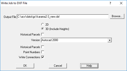
Historical Parcels
Tick this box to export the historical parcels.
Version
You can export the DXF file in different versions
Autocad Release 6
Autocad Release 14
Autocad 2000
The best option is Autocad 2000 for most work.
Points Numbers
Tick this box to export the point numbers as text items next to the point.
Write Connections
Tick this box to export the connection lines in the parcels (999).